
Redistricting Information
The board approved districts are available in a variety of digital formats from the Stanislaus County Open Data Portal
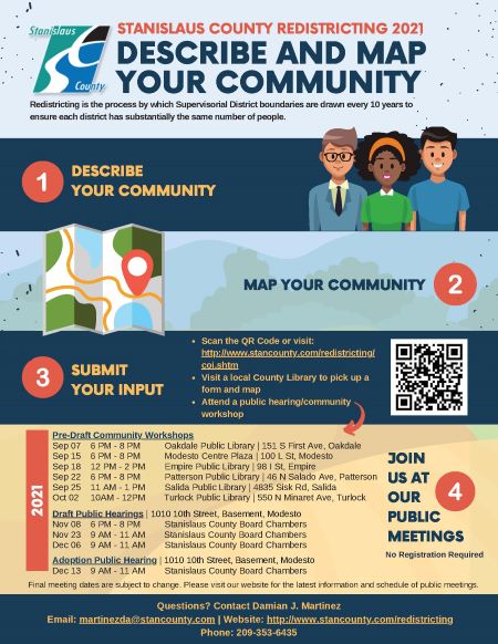
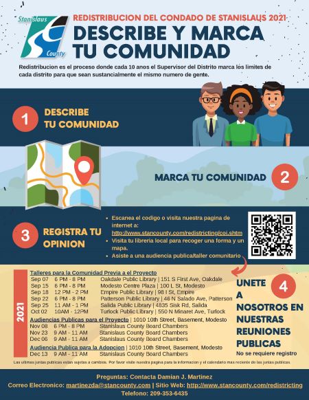
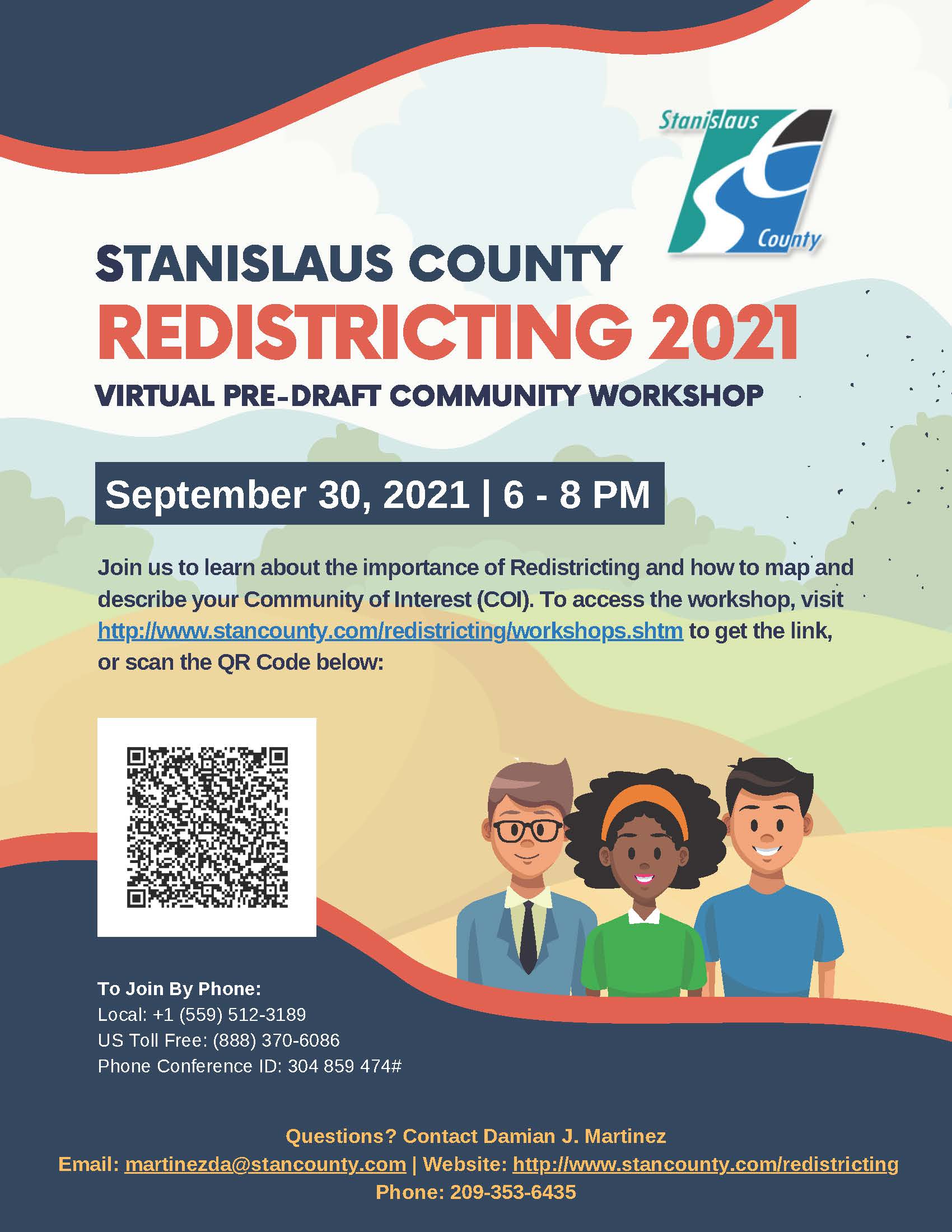
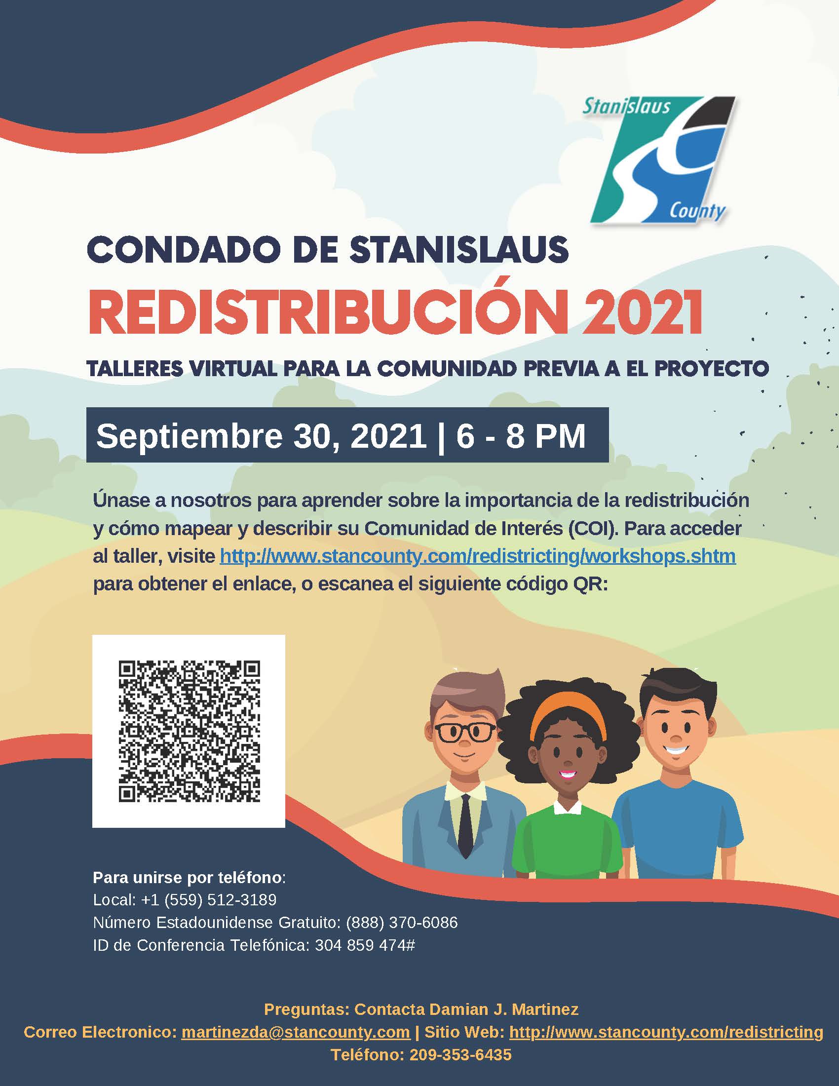
Every ten years, districts must be redrawn so that each district is substantially equal in population. This process, called redistricting, is important in ensuring that each board member represents about the same number of constituents. In Stanislaus County, the Board of Supervisors is responsible for drawing supervisorial districts. Redistricting is done using U.S. Census data, which is released around March 31, 2021. For the County, the redistricting process must be completed by December 15, 2021
Redistricting determines which neighborhoods and communities are grouped together into a district for purposes of electing a board member. The Board of Supervisors will seek input in selecting the next district map for our supervisorial districts. You have an opportunity to share with the Board of Supervisors how you think district boundaries should be drawn to best represent your community.
FAIR MAPS Act (CA Elections Code 21500-21509)
- Population equality shall be based on the total population of residents of the county as determined by the most recent federal decennial census for which the redistricting data described in Public Law 94-171 are available
- Compliance: Compliance with United States Constitution, the California Constitution, and the federal Voting Rights Act of 1965 (52 U.S.C. Sec. 10301 et seq.)
- To the extent practicable:
- Supervisorial districts shall be geographically contiguous. Areas that meet only at the points of adjoining corners are not contiguous. Areas that are separated by water and not connected by a bridge, tunnel, or regular ferry service are not contiguous.
- The geographic integrity of any local neighborhood or local community of interest shall be respected in a manner that minimizes its division. A “community of interest” is a population that shares common social or economic interests that should be included within a single supervisorial district for purposes of its effective and fair representation. Communities of interest do not include relationships with political parties, incumbents, or political candidates. The geographic integrity of a city or census designated place shall be respected in a manner that minimizes its division.
- The geographic integrity of a city or census designated place shall be respected in a manner that minimizes its division.
- Supervisorial district boundaries should be easily identifiable and understandable by residents. To the extent practicable, supervisorial districts shall be bounded by natural and artificial barriers, by streets, or by the boundaries of the county.
- Supervisorial districts shall be drawn to encourage geographical compactness in a manner that nearby areas of population are not bypassed in favor of more distant populations.
- The board shall not adopt supervisorial district boundaries for the purpose of favoring or discriminating against a political party.
Residents have the opportunity to provide input on what kind of boundaries should be drawn to best represent their community. We encourage the community to:
| Allocation | The process of distributing information available for one level of geography to a lower level. |
| Alternative Population Base | A count other than total population from the federal decennial census that is used for redistricting. |
| Apportionment | The process of assigning seats in a legislative body among pre-existing political subdivisions such as states or counties. In the past, some states assigned districts on the basis of county boundaries and therefore continue to call their redistricting process by the name of apportionment. |
| At-large | When a district elects more than one member, all candidates run against each other on one ballot, and they are elected by the whole population of the district. |
| Census | A complete count or enumeration of the population; the federal census is mandated by the U.S. Constitution in Article 1, section 2. |
| Census block | The smallest and lowest level of geography defined for decennial census tabulations. States may have input into the boundaries through the first phase of the Redistricting Data Program—the Block Boundary Suggestion Project (BBSP). The Census Bureau provides redistricting data down to the block level, which is the lowest level of census geography. Blocks can have any population, including no people. |
| Census block group | Block Groups (BGs) are statistical divisions of census tracts, and generally contain between 600 and 3,000 people. BGs tend to follow neighborhoods. They are used to present data and control block numbering. A block group consists of clusters of blocks within the same census tract that have the same first digit of their four-digit census block number. Most BGs were delineated by local participants in the Census Bureau's Participant Statistical Areas Program. |
| Census Bureau | The U.S. Bureau of the Census, which part of the Department of Commerce, conducts the decennial Census of Population and Housing as well as numerous ongoing projects for the federal government. The mission for the Bureaus is to “Count Everyone Once, Only Once and in the Right Place” in the decennial census. |
| Census geography | The geographic units for which census information is tabulated and reported with several hierarchies; the most basic is census block to census block group to census tract to county to state. |
| Census tract | Census tracts are small, relatively permanent geographic entities within counties (or the statistical equivalents of counties) delineated by a committee of local data users. Generally, census tracts have between 2,500 and 8,000 residents and boundaries that follow visible features. When first established, census tracts were to be as homogeneous as possible with respect to population characteristics, economic status, and living conditions. Tracts were first defined in 1970 and the Census Bureau maintains them as consistently as possible across the decades. |
| Commission | A statutory or constitutional body charged with researching, advising or enacting policy. Redistricting commissions have been used to draw districts for legislatures and Congress. |
| Communities of Interest | Geographical areas, such as neighborhoods of a city or regions of a state, where the residents have common demographic and/or political interests that do not necessarily coincide with the boundaries of a political subdivision, such as a city or county. |
| Compactness | Having the minimum distance between all the parts of a constituency (a circle, square or a hexagon are examples of very compact district). Various methods have been developed to measure compactness. |
| Contiguity | All parts of a district being connected geographically at some point with the rest of the district. Limits on contiguity by point or by water vary by state. |
| Cracking | A term used when the electoral strength of a particular group is divided by a redistricting plan |
| Deviation | The measure of how much a district or plan varies from the ideal population, however defined, per district. Deviation can be expressed as an absolute number or as a percentage. |
| District | The boundaries that define the constituency from which a public official is elected. |
| Effective minority district | A district that allows minority voters to elect its preferred candidate of choice. |
| Gerrymander | A term of art to describe a plan or a district intentionally drawn to advantage one group or party over another, sometimes identified by bizarre shapes. |
| GIS | Geographic Information System. Computer software used for creating or revising plans and analyzing geographically oriented data. |
| Ideal population | The total population or alternative for the state or top-level jurisdiction divided by the number of seats in a legislative body. |
| Legislative body | Any entity that performs governmental legislative duties and whose membership is elected by the people; aka representational body. |
| Majority-minority districts | Term used by courts for seats where a group or a single racial or language minority constitutes a majority of the population. (These are also referred to as “effective districts.”) |
| Metes and bounds | A detailed and very specialized description of district boundaries using specific geographic features and street directions as are usually found in describing real property for legal purposes. |
| Minority opportunity district | A district with at least a 50 percent minority citizen voting age population. |
| Multimember district | A single district that elects two or more members to a legislative body |
| Natural boundaries | District boundaries that include natural geographic features such as bodies of water, mountains, etc. |
| Apportionment | A constitutional standard established by the U.S. Supreme Court that means all districts for representational bodies should be approximately equal in population. The degree of equality may vary in congressional plans vs legislative/local plans. |
| Overall range | The difference in population between the largest and smallest districts in a districting plan in either absolute (persons) or relative (percentage) terms. |
| Packing | A term used when one group is consolidated as a super-majority in a smaller number of districts, thus reducing its electoral influence in nearby districts. |
| Partisan gerrymandering | See gerrymander. |
| Plan | A set of boundaries for all districts of a representational body, aka map. |
| PL 94-171 | Federal law enacted in 1975 requiring the U. S. Bureau of the Census to provide the states with data for use in redistricting as well as mandating the program where the states define the geography for collecting data. |
| Plurality | The margin by which the votes for the winning candidate exceeds the votes for the losing candidate with the highest number of votes; if the winner receives more than 50% of the total votes they win with a majority, otherwise they win with a plurality. |
| Racial Gerrymandering | See gerrymander. |
| Reapportionment | See apportionment. |
| Redistricting | The redrawing or revision of boundaries for representational districts. |
| Sampling | Technique or method that measures part of a population to estimate the entire population. |
| Section 2 of the Voting Rights Act (VRA) | Part of the federal law that protects racial and language minorities from discrimination by a state, or other political subdivision, in voting practices. |
| Section 5 of the Voting Rights Act (VRA) | Part of the federal law that requires certain states and localities to pre-clear all election law changes with the U.S. Department of Justice or the federal district court for the District of Columbia before those laws take effect. The provision has become limited in scope since the 2013 Shelby County v. Holder decision where the U.S. Supreme Court invalidated Section 4(b), which delineates the coverage of the section. This decision effectively suspended Section 5 of the VRA. |
| Single-member district | District electing only one representative; in the U.S. House states that are only apportioned the constitutional minimum of one seat are now frequently referred to as at-large states. |
| Single-member election | Election in which only one candidate is elected. While this is how all elections are held in single-member districts, it can also occur in multi-member districts if seats within the district are uniquely designated and not all are elected at the same time. |
| Standard deviation | A statistical formula measuring variance from the average for the entire set of data. |
| Tabulation | The totaling and reporting of the census data from individual responses for all levels of census geography. |
| TIGER | Topologically Integrated Geographic Encoding and Referencing. The system and digital database developed at the U.S. Census Bureau to support computer maps used by the census. |
| VAP | Voting Age Population. The number of persons 18 years of age and over. |
| Voting District (VTD) | Voting District. A census term for a geographic area, such as an election precinct, where election information and data are collected; boundaries are provided to the Census Bureau by the states. Since boundaries must coincide with census blocks, VTD boundaries may not be the same as the election precinct and may include more than one precinct |
California has made all redistricting data available at the CA Statewide Database. The data that is used for Stanislaus County Supervisorial Redistricting is available at the following links:
- Adjusted Citizen Voting Age Population Data
- Adjusted, P.L. 94-171 Redistricting Data
- The board approved districts are available in a variety of digital formats from the Stanislaus County Open Data Portal
Damian J. Martinez
Senior Management Consultant
Chief Executive Office
1010 10th Street, Suite 6800, Modesto, CA, 95354
: (209) 353-6435
: martinezda@stancounty.com

Pre-Draft Community Workshops and Public Hearings
The meeting has been moved to Zoom:
Join Webinar